More About Kingaroy


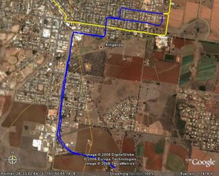
My previous post was the Motion Based Maps, and this post is the Google Earth Maps.
A close inspection of Google Earth indicates that I was running on the verges of the road, and thus through some house properties on the yellow run, although I swear I was running on the roads and a bike track on the purple run. Anyway, both maps give an indication of where I ran, and I'm pretty sure the distance was accurate.
While at Kingaroy, I was shown Jaimie's Parent's house in Gladstone, using Google Earth, he picked it up having local knowledge of the area.
He was also having a look at a possible area that he might move to for job purposes.
It just goes to show that people other than runners, use this technology.
Until Next Time.

1 Comments:
Amazing stuff - all this new technology! Tried out a GPS Navman in the car recently and it was so clever!
Post a Comment
<< Home